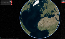
3D Map Overview
3D Viewer
| Item | Description | ||
|---|---|---|---|---|
1 | Search for specific locations on the globe. Enter the location name in the field (e.g., Los Angeles) then press Enter or select the Search icon
| |||
2 | Position Indicator | Shows the coordinates on the globe corresponding to the current mouse position. As you move the mouse across the globe in the viewport, the corresponding latitude and longitude coordinates appear. | ||
3 | Elevation Indicator | Shows the elevation on the globe, in meters, at the current mouse position. The elevation value updates as you move the mouse. Elevation values are only available at higher zoom levels; at lower zoom levels, "Elevation: Not Available" appears in the Elevation Indicator. | ||
4 | Home | Select the Home icon | ||
5 | Navigation Instructions | Select the Question icon | ||
6 (not shown) | You can copy coordinates and elevation values to the clipboard using the Copy tool. Right-click the desired area, and in the context menu, select Lat/Lon or Elevation. Your cursor changes to crosshairs A green rectangle indicates the selected point in the viewport, and a dialog shows the copied data. Copied coordinates appear with Lat/Lon values. Copied elevations measure values in meters and feet. To center the viewport on the point you selected, select the Focus Camera on Object button on the left side of the Coordinates dialog. |
