Taking a Snapshot
Use the Snapshot tool to create a custom, close-up collage of images.
| View-only users cannot take snapshots. |
- Zoom to level 13 or higher.
In the Carousel toolbar, select the Take Snapshot icon
 . The New Snapshot dialog opens.
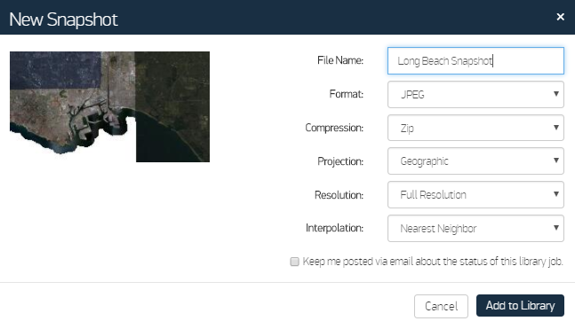
New Snapshot Dialog
In the File Name field, enter a name for the file.
Do not use special characters in file names. Special characters can prevent you from downloading files from your library, or may cause errors when downloading imagery. Maxar replaces special characters with underscores.
Select additional options for your image's Format, Compression, Projection
 More Information
Format An image format supported by your exploitation tool. This format will be used when the image is delivered to your library. Depending on your account and the type of item you are saving, format options may include:
GeoTIFF (compressed) JPEG compression with YCbCr color space and 95% quality
JPEG Compressed format with a small file size; suitable for inserting into PowerPoint and documents
MrSid Compressed 15:1; a good choice for large areas where file size is an issue
JPEG2000 Compressed; a good choice for large areas where file size is an issue
GeoPDF A georeferenced PDF for use in tools that can read that format
NITF 2.1 (NPJE JP2 4:1) Embedded metadata; useful for military applications that require this format
NITF 2.1 (NPJE JP2 15:1) Embedded metadata; useful for military applications that require this format and when file size is too large with 4:1 compression
RPF 0.5 Meter, 1 Meter, or 5 Meter Suitable for those who need a CIB-like replacement
PowerPoint Output is a PowerPoint slide with a screenshot on top, and marked Unclassified. The slide size and aspect ratio match your viewport (snapshot only)
Google Earth Compression, projection, and resolution are Google Earth defaults(snapshot only)
Compression The compression option for packaging files. Options include TAR (for Linux/Unix or Max) or ZIP (for Windows).
Projection The projection type, which defines how the satellite imagery is mapped to the earth. Options include:
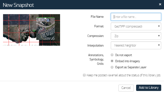
Do one of the following, depending on whether or not annotations are visible in the viewport
- No Visible Annotations Proceed to Step 6
Visible Annotations In the Annotations, Symbology, Grids section, select how the annotations will be handled during export:

New Snapshot Dialog with Options for Annotations and Grids
(Optional) If you want to receive email notifications with updates about the status of the library job, select the checkbox.
This option is not available if you have not provided an email address in your user profile.
- Select Add to Library.
More Information
- Snapshots of rotated images are limited to JPEG and PowerPoint. Likewise, grids and annotations can only be embedded.
- Snapshots that contain the MGRS grid are marked with the centroid of the viewport in the bottom left corner of the snapshot, along with the gridline labels.
- Whenever you export annotations and grids, the product format is limited to the following options:
- GeoTiff (compressed) or JPEG Defaults to WGS 84 projection and low resolution; embed in the imagery or export as a separate layer.
- PowerPoint Creates a PowerPoint slide with a screenshot on top with grids and annotations embedded. The slide size and aspect ratio match your viewport.
- Google Earth Sets the default format to KML with grids and annotations embedded.