ESRI REST Services
ArcGIS has its own RESTful APIs which implement the functionality of WMS, WMTS, and WFS. G-EGD has implemented much of ESRI's API functionality in order to better support users of ArcMap and users of ArcGIS Online. We also have the ability to pull data from ArcGIS Server endpoints into G-EGD as Supplemental Layers using these same APIs.
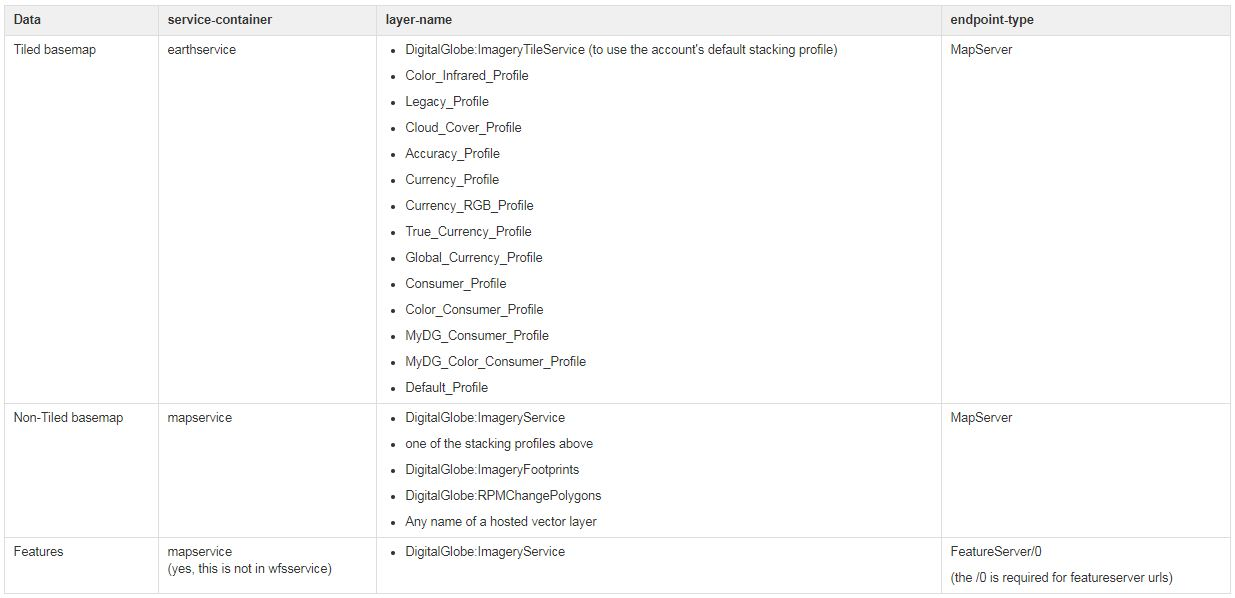
Tile BaseMap
For the tiled basemap service, ArcMap internally will load the URL https://evwhs.digitalglobe.com/earthservice/gis/<CONNECTID>/rest/services/DigitalGlobe:ImageryTileService/MapServer (which is roughly equivalent to the WMTS GetCapabilities call) before it starts loading tiles using this ArcGIS API call which is the equivalent of the WMTS GetTile function.
Non-Tiled BaseMap
For the non-tiled map services (WMS proxy for hosted vector layers, RPM, etc), ArcMap internally will load the URL https://evwhs.digitalglobe.com/mapservice/gis/<CONNECTID>/rest/services/<layerName>/MapServer (which is roughly equivalent to the WMS GetCapabilities call) before it starts querying the MapServer using this ArcGIS API call which is the equivalent of the WMS GetMap function.
Features
For the Feature Service (WFS proxy for finished Feature footprints), ArcMap internally will load the URL https://evwhs.digitalglobe.com/mapservice/gis/<CONNECTID>/rest/services/DigitalGlobe:ImageryService/FeatureServer/0 (which is roughly equivalent to the WMS GetCapabilities call) before it starts querying the FeatureServer using this ArcGIS API call which is the equivalent of the WFS GetFeature function.
| For more information on the ArcGIS API call equivalent of the WFS GetFeature function, please visit http://resources.arcgis.com/en/help/arcgis-rest-api/index.html#/Query_Feature_Service/02r3000000w5000000/ |
ArcGIS Online
To use the REST API endpoints in ArcGIS Online:
- Open your ArcGIS web map viewer (maps.arcgis.com/home/webmap/viewer.html).
- Choose Add > Add Layer from Web.
Enter the layer URL template depending on the data you want to see:
Example
https://evwhs.digitalglobe.com/<service-container>/gis/<CONNECTID>/rest/services/<layerName>/<endpoint-type>
Data Available
- If you are adding a tiled map service, select Use as Basemap.
- Select Add Layer.
- If prompted, enter your credentials.