Introduction
About OGC
The Open Geospatial Consortium (OGC) is an international voluntary consensus standards organization that originated in 1994. In the OGC, more than 400 commercial, governmental, nonprofit and research organizations worldwide collaborate in a consensus process encouraging development and implementation of open standards for geospatial content and services, GIS data processing and data sharing.
The Open GRASS Foundation (OGF), a predecessor to OGC, was established in 1992. From 1994 to 2004 the organization also used the name Open GIS Consortium.
The OGC Process
The OGC exists to enable a fast, effective, inclusive, user-driven process to develop, test, demonstrate, and promote the use of geospatial information and services by using OpenGIS® Standards.
The OGC has defined the standards around different GIS cloud services by following the process of identifying and addressing existing problems in the GIS industry. The process is:
- Identify the Problem
- Craft a Solution
- Evaluate the Proposed Solution
- Implement Standards
One of the major problems identified and addressed is interoperability. The following topics have been discussed and prioritized as part of identifying and addressing the interoperability problem:
- Sharing maps on the Web
- Delivering data to different systems easily
- Deriving a common language to speak about geospatial data or services
- Finding and pulling together data from our automated sensors
Details About Interoperability
Interoperability at a technical level refers to the ability for a system or components of a system to provide information portability and inter-application as well as cooperative process control. Interoperability comprises intercommunication at communication level protocol, hardware, software, and data compatibility layers.
Interoperability, in the context of the OpenGIS Specification Program, is software components operating reciprocally to overcome tedious batch conversion tasks, import/export obstacles, and distributed resource access barriers imposed by heterogeneous processing environments and heterogeneous data.
Interoperability with respect to geoprocessing refers to the ability of digital systems to 1) freely exchange all kinds of spatial information and 2) cooperatively, over networks, run software capable of manipulating such information.
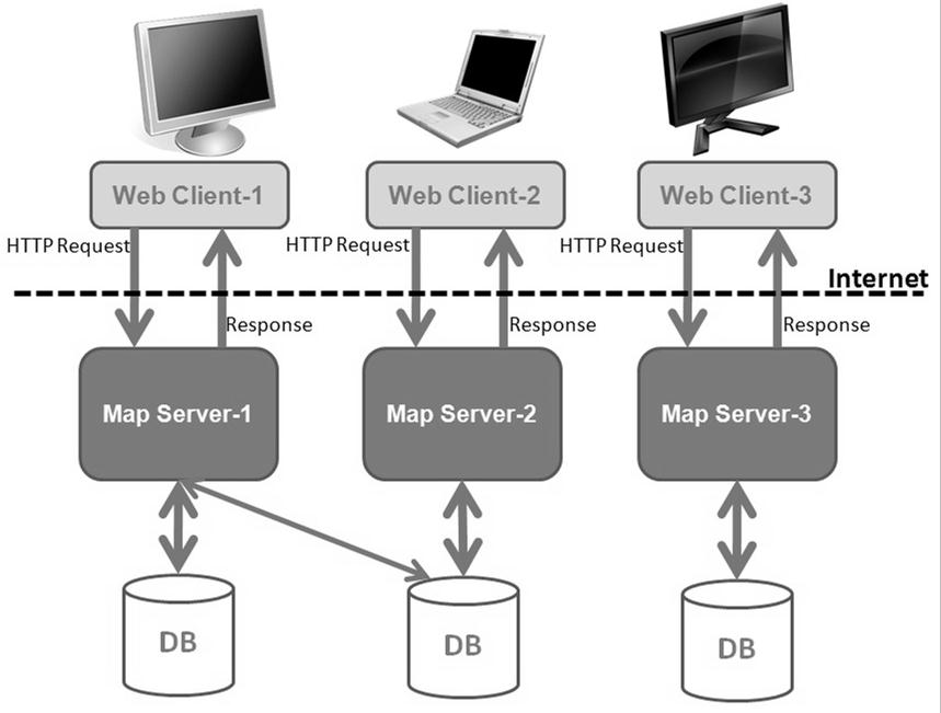
Organizations and companies have been providing online mapping services for years. These Web mapping systems have been implemented as a set of proprietary systems. As a result of this isolated development, online mapping services from different vendors are not interoperable. Thus, many technology islands are created and preserved, and many users are locked into single-vendor solutions. This situation is slowly improving but, unfortunately, most Web mapping applications today are still inseparably tied to a specific server implementation. In other words, the Web client is hard-coded to interact with a particular vendor's proprietary map server implementation.
Figure 2.1 shows a scenario where the user must run three different Web applications in order to access the data and functionality provided by three different server implementations. In this scenario, there is very little interoperability or reuse of the Web client and server implementations.
Only Web Client-1 allows access to more than one database. Unfortunately, Web Client-1 may not provide all the functionality that Web Client-2 and Web Client33 offer. Even with Web Client-1's ability to access data of interest from multiple databases, the user must still run three different applications from the different Web clients to perform a given task.
Interoperability
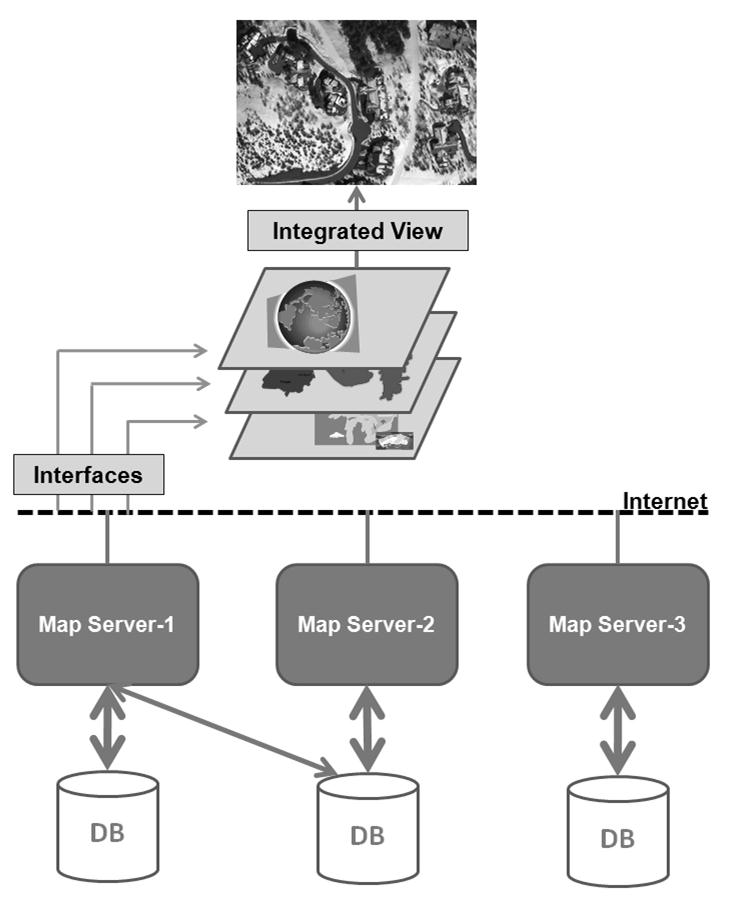
To address this problem, the OGC developed a non-proprietary Web mapping approach based on open interfaces, encodings and schemas. The OGC Specification Program and Interoperability Program provide an industry consensus process to plan, develop, review and officially adopt OpenGIS Specifications for interfaces, encodings and schemas that enable interoperable geoprocessing services, data, and applications.
With standards-based interoperable Web mapping, each map server implements a common interface, a messaging protocol such as the WMS interface for accepting requests and returning responses. Now, the same client has Web access to potentially all available map servers and multiple data sources, where each map server is accessed by a client through the common interface.
This approach allows, among other things, a way for the user to run a single client that accesses all the capabilities of each server. This allows a more open application environment where the best features of available Web services can be flexibly combined in innovative and previously unimagined ways to solve novel and increasingly complex problems.
Interoperable Distributed Mapping
OGC Standards and Specifications
OGC® Standards and Specifications are technical documents that detail interfaces or encodings. Software developers use these documents to build support for interfaces or encodings into their products and services. These specifications are the main "products" of the Open Geospatial Consortium and have been developed by the membership to address specific interoperability challenges. The OGC documents are offered at no cost and are available to everyone.
OGC Document Type | Description |
|---|---|
OpenGIS Implementation Standard | A document containing an OGC consensus, technology-dependent standard for application programming interfaces and related standards based on the Abstract Specification or domain-specific extensions to the Abstract Specification. There are five subtypes: Interface, Encoding, Profile, Application Profile, and Application Schema. |
Abstract Specification | A document (or set of documents) containing an OGC consensus, technology-independent standard for application programming interfaces and related standards based on object-oriented or other IT-accepted concepts. It describes and/or models an application environment for interoperable geoprocessing and geospatial data and services products. |
Best Practices | A document referring to the use and/or implementation of an adopted OGC document. Best Practices Documents comprise an official position of the OGC and thus represent an endorsement of the content of the paper. |
Discussion Papers | A document containing discussion of some technology or standard area for release to the public. Discussion Papers do not represent the official position of the OGC and contain a statement to that effect. |
White Papers | A publication released by the OGC to the public that states a position on a social, political, technical or other subject, often including a high-level explanation of an architecture or framework of a solution. |
OGC Standards
OGC Standards are written for a more technical audience and detail the interface structure between software components. An interface specification is considered to be at the implementation level of detail if, when implemented by two different software engineers unaware of each other, the resulting components plug and play with each other through that interface.
Abstract Specification
The OGC Technical Committee (TC) has developed the OGC Abstract Specification architecture in support of its vision of geospatial technology and data interoperability. The Abstract Specification provides the conceptual foundation for most OGC specification development activities. Open interfaces and protocols are built and referenced against the Abstract Specification, thus allowing interoperability between different brands and different kinds of spatial processing systems. The Abstract Specification provides a reference model for the development of OGC Implementation Specifications.
OGC Reference Model (ORM)
The OGC Reference Model (ORM) provides a framework for the ongoing work of the OGC. The ORM describes the OGC Standards Baseline (SB) focusing on the relationships between the OpenGIS Specification documents. The OGC SB consists of the approved OGC Abstract and Implementation Specifications as well as OGC Best Practices documents. Best Practices documents are official positions of the OGC members and are often provided as supporting technical information for the adopted Specifications.
The ORM has the following advantages and purposes:
- Provides an overview of OGC Standards Baseline
- Provides insight into the current state of the work of the OGC
- Serves as a basis for coordination and understanding of the documents in OGC SB
- Provides a useful resource for defining architectures for specific applications
| For detailed information on OGC standards and specifications, visit http://www.opengeospatial.org/standards. |