Web Map Tile Service
The Maxar Web Map Tile Service (WMTS) defines a set of functions that clients may use to return actual Features with geometry and attributes that can be used in any type of geospatial analysis.
Any client making requests that conform to the OGC WMTS specification can interact with the WMTS server. Web-based client-server architecture is a typical example of the structure of a Web Map Tile Service application.
A Typical Structure of a WMTS Application
In the WMTS scenario, the client application requests desired information from the Web Map Tile Service server. The WMTS server retrieves the appropriate information from the database including capabilities, Tile and FeatureInfo and responds to the request with relevant information.
The goal of providing a WMTS-enabled service is to offer high performance while being scalable. Therefore, servers must be able to return Tiles quickly. A good way to achieve that is to use locally stored, pre-rendered Tiles that will not require any image manipulation or geoprocessing.
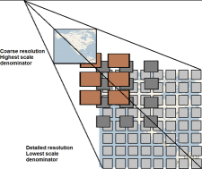
The purpose of a WMTS service is to serve Maps divided into individual Tiles.
Advantages of WMTS
The Maxar WMTS provides raster imagery data at multiple resolutions in predefined imagery Tiles (PNG or JPEG formats), making it more scalable and high-performing than Web Map Service (WMS). The WMTS is similar to WMS, but it allows better server performance in applications that involve several simultaneous requests.
To improve performance, WMTS returns small pre-generated images or reuses identical previous requests that follow a discrete set of Tile matrices, rather than creating a new image for each request.
This service is optimized for sending rapid image Tile delivery information from the cache for display on portals or applications where server response time is of primary concern.
WMTS Service Divided Into Tiles
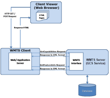
WMTS Client-Server Architecture
The following architecture depicts a sample integration of WMTS client and server applications. Client Viewer is a series of HTML pages running inside a web browser that can interact with a WMTS server via client application through HTTP calls. The WMTS client manages the interactions with WMTS interfaces through HTTP requests and dynamically generates HTML that can run in a web browser.
The WMTS server accepts requests from the WMTS client and the viewer client in the form of HTTP URL strings, and returns results encoded as XML, PNG, GML, and so on.
Sample WMTS Client-Server Application
WMTS Service Details
The OGC standard for WMTS defines a set of required and optional operations. The Maxar WMTS supports the following operations:
GetCapabilities. The GetCapabilities request is used to obtain information about the available Map Tile types and supported operations.
GetTile. The GetTile request is used to obtain an actual imagery Tile. Tiles are available for a subset of the layers provided by the online catalogs.
| See Basic Service Elements for about of the common parameters for an OGC-compliant service. |


