Map Options Menu
In the Map Options menu, there are several different ways to view the background and understand the location on the globe that you are looking at. Select menu items or toggle options on and off to customize your view. Some options apply at all altitudes, while others apply only at higher altitudes or lower altitudes.
- On the header bar, select Map Options.
Map Options Menu Overview
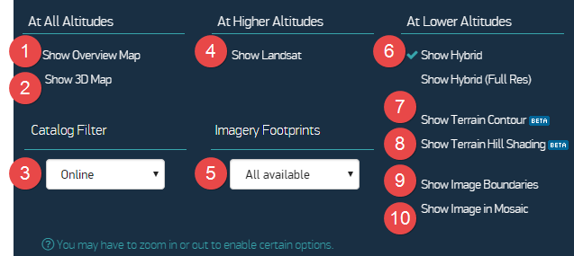
Map Options Menu
| Item | Description | |||||
|---|---|---|---|---|---|---|---|
1 | Overview Map | The overview map in the bottom right corner of the screen shows your current location on the globe at 5 zoom levels higher than your current zoom, with the current viewport highlighted in orange.
| |||||
| 2 | Show 3D Map | Enable the 3D map to view imagery on a 3D globe orthorectified to a Digital Elevation Model (DEM). Elevation values are available in the map viewport when you move your mouse across the screen, and you can copy the elevation value to the clipboard at any point. See Opening the 3D Map. | |||||
| 3 | Catalog Filter | Select the imagery catalog you want to view, including archive imagery and stereo imagery. See Filtering Imagery. Depending on your zoom level, you can interact with imagery in different ways:
| |||||
4 | Show Landsat | Turn on Landsat if you want to see imagery instead of the basemap at zoom levels 3–10. Your selection is saved to your profile for future sessions. | |||||
| Imagery Footprints | Depending on your account, imagery may not be available everywhere. To locate areas with available images, select the Imagery Footprints drop-down menu, then select a timeframe. Depending on your zoom level, you can interact with imagery in different ways:
| |||||
| Show Hybrid Show Hybrid (Full Resolution) | Hybrid shows city and street names at zoom levels 11–16 (on by default). Hybrid Full Resolution shows city and street names at zoom levels 17–20 (off by default). The defaults provide a navigation aid as you zoom in until you reach full resolution (zoom level 17), where you might have sufficient context and no longer need map cues. The toggles allow for other use cases where you might want to never see hybrid or to see hybrid at all zoom levels. Turn on to show or turn off to hide.
| |||||
| Enable at zoom level 13 or higher to overlay terrain contours on top of any imagery in the viewport. | ||||||
| Enable at zoom level 13 or higher to overlay hill shading on top of any imagery in the viewport. | ||||||
| Show Image Boundaries | Enable at zoom levels 13–20 to see image outlines and acquisition date. | |||||
| Show Image in Mosaic | Enable at zoom levels 13–20 to view the seamlines of a mosaic when one is selected in the viewport. Mosaic images are labeled "Mosaic" on the Carousel thumbnails (see Working with Imagery in the Carousel) and show "Mosaic" in the source column in Advanced Search. |