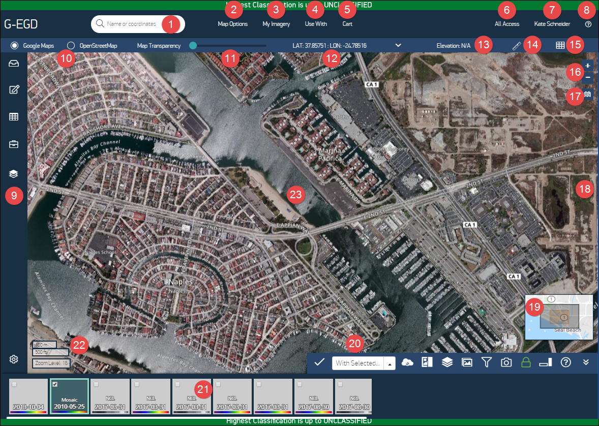
1 | Search Box | Enter search criteria. | Searching for a Location |
2 | Map Options | Manage map-related functionality. | Map Options Menu |
3 | My Imagery | Manage image-related functionality, such as accessing alerts and bookmarks, downloading imagery from your library, saving tilesets, ordering imagery, and performing advanced searches. | Alerts Bookmarks Library Tilesets & GeoPackages Orders Advanced Search |
4 | Use With | View imagery with third-party services, such as Google Earth. | Third-Party Tools |
5 | Cart | View your shopping cart and order history. Only available to accounts with archive access. | Orders |
| Account Name | Switch accounts. | Switching Accounts |
| User Name | Manage your user profile, change your password, and log out. | Account Management |
| Help | Open the Help menu. - Getting Started Overlays tooltips on the viewport. Click anywhere to close.
- Keyboard Shortcuts Opens the Keyboard Shortcuts list.
- Send Feedback Opens the Feedback dialog. Complete the form or contact us at 1-866-810-2297 or deftechsupport@maxar.com.
- User Guides & Licenses View the user guide or license. Select the link to download the file.
- About EV WebHosting See the current software version.
| |
| Side Panel | Open side panel tools (e.g., Dashboard, Annotations). | |
| Basemap | The basemap shows by default at all altitudes. You can set your basemap to Google Maps, OpenStreetMap, and Natural Earth. Your selected basemap drives the search functionality. | |
| Map Transparency | Adjust the transparency of the basemap. | |
| Coordinates | View the map coordinates at your cursor location. Select the drop-down to select a preferred unit: decimal degrees (the default), lat/lon degrees/minutes/seconds, Military Grid Reference System (MGRS), and degrees decimal minutes. | Using Map Coordinates Copying Latitude & Longitude Using the Cursor |
| Elevation | View the elevation at your cursor. | |
| Measure Distance | Measure the distance between points in the viewport. | Measuring Distances |
| Grid Toggle | Turn on the reference grid. The MGRS grid only displays at zoom levels 9–20. | Viewing the Coordinate Reference Grid |
| Zoom Tool | Zoom in and out in the viewport. | Zooming & Panning in the Viewport |
| Draw Polygon Tool | Define an area of interest by drawing a polygon, dragging a rectangle, entering a well-known text string, uploading a shapefile, or using the map viewport. You can also measure the distance between two or more points, open the copy lat/lon tool, or view metadata at any map location. | Defining an Area of Interest Measuring Distances Copying Latitude & Longitude Using the Cursor Working with Imagery in the Carousel |
| Vertical Carousel | If you have your Carousel orientation set to "vertical," the Carousel displays here at zoom levels 13–20. | Overview of the Carousel |
| Overview Map | An aid to understanding your location. The overview map is not shown at zoom level 3 (the whole earth). | Map Options Menu |
| Horizontal Carousel | If you have your default Carousel preference set to "horizontal," the Carousel displays here at zoom levels 13–20. | Overview of the Carousel |
| Carousel | Shows images that intersect with the map view. Hover over any thumbnail to access the Image Menu for more options. | Working with Imagery in the Carousel |
| Current View Data | Data about the current view, including the current zoom level. | Zooming & Panning in the Viewport |
| Viewport | View imagery in this area. | |