Introduction
ImageConnect is an ArcMap extension that brings georeferenced high-resolution satellite and aerial imagery into your GIS project using OGC-compliant web services.
ImageConnect does several things for you beyond connecting directly to web services:
- When you are zoomed into an AOI, shows the most recent data available (Default Imagery layer).
- Lists older images for your AOI that are available online, which you can select and view, as well as filter (Additional Imagery layer).
- Allows you to work with a saved, static set of images as a "source package" for feature extraction.
- Provides access to metadata for each image.
- Allows you to save a mashup to your own "library" for download.
- Provides a save and download capability for full images.
- Lets you create and download "inclusion areas" to designate expanses where you've used an image from the Additional Imagery layer for digitizing.
- Provides for exporting a shapefile containing footprints and metadata for the Default Imagery layer over your AOI.
The ImageConnect toolbar provides a simple interface to work with the tool.
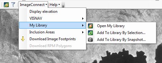
ImageConnect Toolbar with Library Menu Expanded
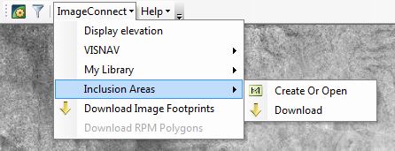
ImageConnect Toolbar with Inclusion Areas Menu Expanded
- Open ImageConnect Settings Select the flower icon to specify your connection settings and enter credentials
- Filter Images in the Additional Imagery Group Layer Select the filter icon to open the Filter Additional Imagery pane. You can also turn off the Additional Imagery layer to improve performance. See Filtering Additional Imagery.
- Display Elevation Select to view the elevation of your cursor's location on the map. See Displaying Elevation.
- Displaying VISNAV Layer Select to view the VISNAV global land use/land cover dataset as a layer in your map. See Displaying the VISNAV Global Land Use/Land Cover Dataset.
- Open My Library Select to view and download your saved images. See Working with the Image Library.
- Add to Library by Selection Select to save an image bounded by the selected polygon as a high-resolution raster image. See Saving Imagery to Your Library.
- Add to Library by Snapshot Select to save the data frame view to your library as a high-resolution raster image. See Saving Imagery to Your Library.
- Create or Open Inclusion Area Layer Select to create or select an inclusion area for your AOI. See Working with Inclusion Areas.
- Download Inclusion Areas Select to download the inclusion areas for your AOI. See Working with Inclusion Areas.
- Download Image Footprints Select to download the image footprints for your AOI. See Exporting Project Area Footprints.
- Download RPM Polygons Select to download the Refined Persistent Change Model (RPM) polygons for your map viewport. See Working with the Refined Persistent Change Model.
- Help Provides links to Getting Started and to About ImageConnect.